Scaling Tool


|
Scaling Tool |
|
|
The scaling tool allows you to scale the 2D coordinate system by knowing the distance between 2 landmarks in the video images. After you have scaled the coordinate system, the point coordinates are displayed in the units that you choose.
To scale the coordinate system, follow these steps:
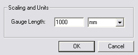
2. The following dialog will be displayed. 3. Enter the length of the scaling gauge. 4. Enter the units used. 5. Click OK. 6. The mouse cursor will change to 7. Click on the first landmark. 8. Click on the second landmark. 9. A scaling gauge will be displayed between the 2 selected landmarks.
To cancel the scaling tool, simply select the scale command again or press ESC. If you need to delete the scaling tool, right-click on the gauge and then select Delete Scale. You can also change the units or gauge length by double-clicking or right-clicking/properties on the gauge.
|